
Wednesday, October 5, 2016
Tuesday, October 4, 2016
Satellites, orbital objects, and space junk

Monday, October 3, 2016
assignment 2 Image: one is from 2015 the other from 1977

 Both photos are of Beijing, the bottom image was taken in 1977, center is well defined. The shape, is cultural with straight edges, customary in Chinese cities. The vegetation appears read with in infrared in the gun. As the you look farther from the center of the city the vegetation gets more dense. There also appears to be mountains in the west because of the shadow and texture of the terrain. The agricultural fields appear in contrast with crops ready to harvest and crops not. Their shape is well defined.
The top photo was taken in 2015, the scale is larger. The center of the city is well defined. Especially the center, where the wall is visible. The cultural shape and association of the wall compared to the rest of the city. There appears to be an attempt of new vegetation growth within the inner city.
Tuesday, September 27, 2016
Palm Jumeirah in the U.A.E.

With the weather getting cold,
We'd all like to live on this mold.
But not all is as nice as you'd think,
Let's hope it doesn't continue to sink!
Analysis: The dark area with intermittent areas of lighter blue is likely water, implying that this is a type of island. The precise nature of the shapes involved in this landmass make it seem like it is certainly man-made and unnatural. If it is water, the colors on the fringe of where the water becomes land (a very light blue) are not typical of dirt nor rock, so it appears to be sand. The sandy beach of the land makes it seem like the geographic location will be a relatively warm temperature, while the numerous marinas, hotels, and resorts surrounding the perimeter beach imply that it is probably a major tourist location.
Info: This is an image of the Palm Jumeirah, a man-made archipelago in the United Arab Emirates. While many people have likely seen this image or even visited, I have always loved the crazy stuff the UAE has done with reclaimed land and I've always thought of this one as one of the coolest.
Monday, September 26, 2016
Thermal Image of the Northeast (9/29)

This image was taken on September 13th by the VIIRS instrument on one of NOAA's satellites. It senses thermal radiation to show variations in temperature across Earth's surface. In this photo of the northeast coast of the US, blue tones signify cooler surface temperatures and yellow tones signify warmer temperatures. It is interesting to see the temperature change between ocean currents, the difference in temperature between ocean and land, and the pockets of heat in densely populated areas. You can also detect lots of relief detail, with valleys being slightly warmer than mountains. Whatever processing was done to assign temperature ranges to different colors really helped create a striking and easily comprehensible image.
The ability to sense thermal radiation is really useful because it helps us visualize phenomena otherwise invisible to us. We can use it to track pollution plumes, land cover change, seasonal changes in a landscape, effects of urbanization, etc.
Deforestation in the Peruvian Amazon

This is a satellite image of a section of new deforestation in the Peruvian Amazon rainforest, captured on August 28, 2013. This imagery may be important for a couple of reasons: 1) This may be an illegal logging operation, and this imagery helps inform people what is happening and where. 2) The imagery helps us know how much deforestation is going on in various forests, which is important to know because deforestation is a cause of global warming.

Wednesday, September 21, 2016
Remote sensing mystery image
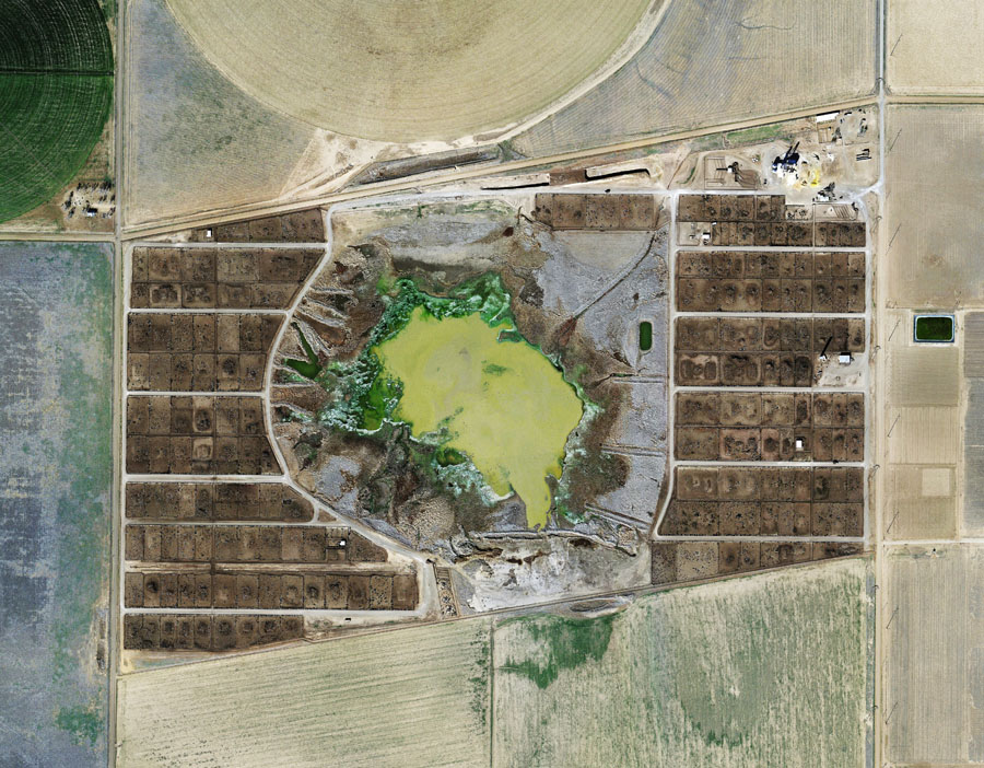
Image by Mishka Henner
This is an image of an animal feed yard operation in Texas. The image was composed of many high-resolution satellite images stitched together by the artist Mishka Henner (http://www.mishkahenner.com/filter/20102015/2013-3) . The scale of the operation, geometric patterns, aesthetic (image orientation), and contrast between the browns of the earth and greens of manure residue is particularly interesting. The picture really communicates the scale of how animal agriculture has transformed the land and removed the production of food from what we consider as "natural" processes. The aerial image reinforces that disjunct feeling of removal, the cows are indistinguishable.


Tuesday, September 20, 2016
The Grand Canal

The Grand Canal in Venice, Italy serves as a transportation service to many of the residents of the city. It's a little under 2.5 miles long, and has an average depth of about 15 feet. The first known settlers of the area came before the Roman age. The city is sinking at around 2-4 mm per year based on the part of the city (the north is sinking slower than the south).
MORE PHOTOS:


Subscribe to:
Posts (Atom)