Tuesday, July 14, 2020

Coronavirus transmission being studied alongside new environmental datasets

Caption: The above image is a visualization of reanalysis data that will be used to investigate what environmental factors are related to the spread of the novel coronavirus.


NASA recently announced a new international initiative to make global environmental data more easily accessible to scientists and researchers.  It was widely reported in March that global air pollution levels dropped during the global economic shutdown and shelter-in-place related to COVID-19.  Now scientists are investigating whether the spread of the coronavirus itself could be tied to large scale, seasonal shifts in humidity or temperature. 

In particular, NASA is pushing the availability of reanalysis datasets, which can be updated with new observations.  It’s not yet clear whether there is any relationship between the rapid spread of the pandemic and the sort of environmental changes that can be tracked in these data.  However, with more remote sensing data on hand – using both ground sensors and satellite imagery – scientists are optimistic that in the long run there will be a better understanding of how seasonal changes might affect the virus.


https://earthobservatory.nasa.gov/features/covid-seasonality

Monday, July 13, 2020

North Korea destroying shared North/South joint liaison office

These satellite images show the Kaesong Industrial Complex in North Korea. This building serves as the North-South Joint Liaison Office was deliberately destroyed by North Korea, using explosives. Satellite images show the building 24 hours before being destroyed. The images also show cargo trucks in the area, which is unusual because cargo trucks are not usually seen in that area. This was an unexpected act, especially since the two countries were trying to better their relations.

Link to article: https://www.geospatialworld.net/blogs/satellite-imagery-north-korea-blows-joint-liaison-office/


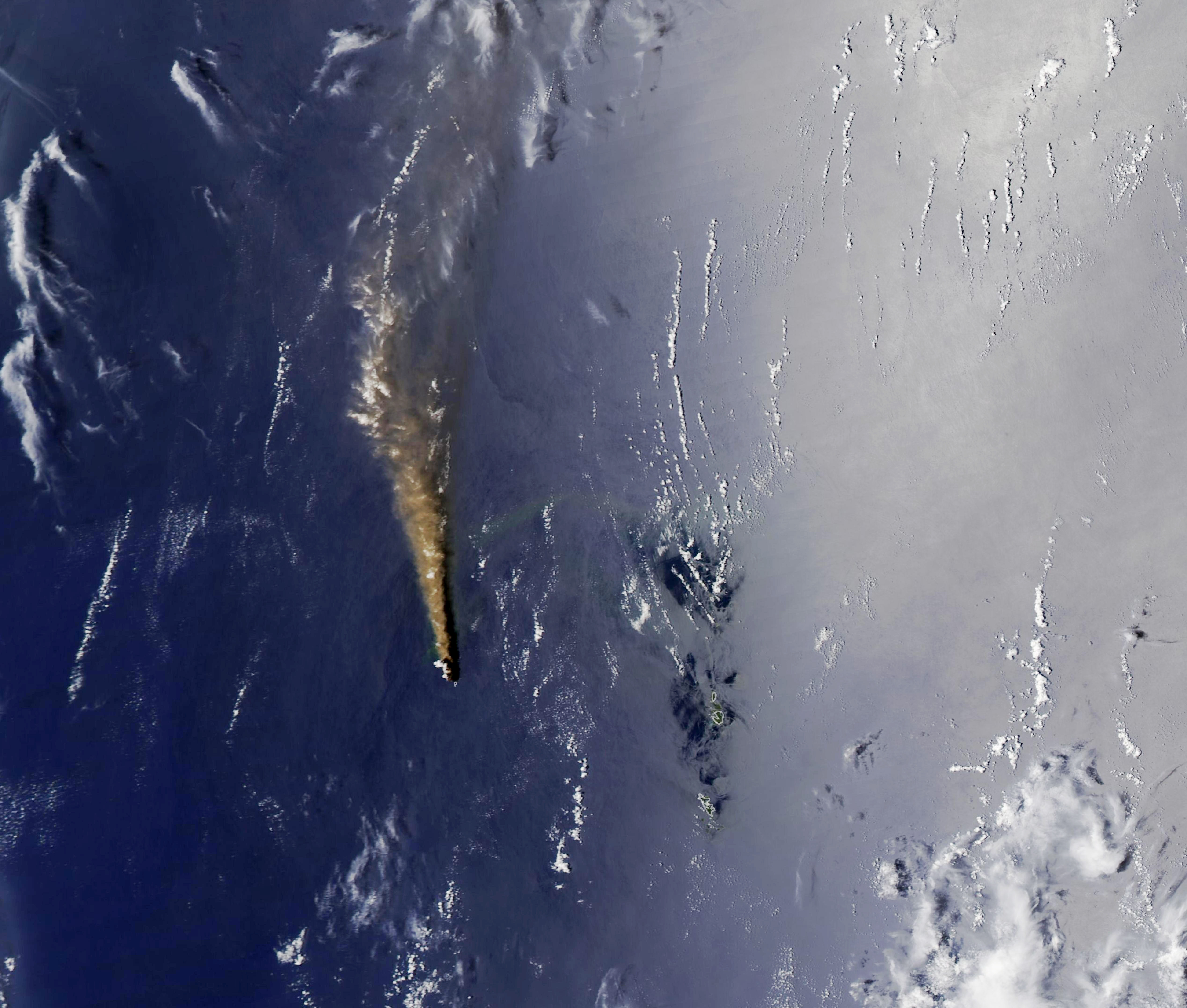
Nishinoshima, a volcanic island in the Pacific Ocean, is fully into its growing years on the Ring of Fire


The Ogasawara Islands in the Pacific Ocean is home to a previously submarine volcano which has accumulated lava flows to the point of breaking the surface as of 2013. 2020 has been a particularly active year for this young island.

What makes it apparent that this is an image of an erupting volcano are the elements present in the image. There's a brown plume radiating north-ward and fades away towards the end. There's a shadow of this plume along its right side. And it's originating from a relatively small speck on the image, in the middle of the ocean. The non-human-made appearance coupled with the global location of the image, along the infamous Ring of Fire, tell us that it's an active volcanic island. For seven years now people have been monitoring this location of the world from above and caught the volcano erupting several times. Given that it's 600 miles from Tokyo, Japan, it's relevant because of the environmental as well as public safety affects. It is also a mere 80 miles from the nearest inhabited island, making it an even more important situation to monitor in coming years. 


Find the original article here: nishinoshima-belches-ash-and-lava

Australian Fires


This satellite image from January 2020 taken by NASA MODIS Satellite published in an Argentinian newspaper, Página 12, shows the Southeastern region of Australia covered in smoke by the wildfires. Although wildfires are not a strange thing in Australia, the unprecedented magnitude of these ones was-  burning over 46 million acres of land during over 4 months .
The smoke from the fires, visible here as the light grey cloud like structure in the center of the image- much larger than the small white regular clouds, took over the Australian sky, and had a plume that even reached Chile and Argentina, and lasted for three months.

NASA Satellite Images Show Rare Cloudless View of Patagonia


Right now it is the winter season in South America, a time when skies are most often cloudy in the southernmost region of the continent. However, the MODIS on NASA's Aqua satellite was able to capture these images recently, providing scientists with a pretty rare glimpse of the Patagonia region from the skies above. This region is located in an area where prevailing westerly winds cause frequent storms that result in year-round issues with cloudy satellite imagery. However, these recent, detailed images were taken following an unusual change in this weather pattern. A high-pressure system occupied the region and helped dry out the air and clear the skies. One researcher even stated that this clear of imagery in the region has not been seen since February of 2019. 

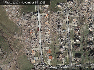
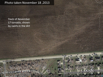
2013 Washington, IL EF-4 Tornado - Bergman

Washington Tornado (Tazewell/Woodford Counties) of 11/17/2013
November 18, 2013. Washington, IL. 1 day post-tornado
Washington Tornado (Tazewell/Woodford Counties) of 11/17/2013
November 18, 2013. Washington, IL. 1 day post-tornado
Washington Tornado (Tazewell/Woodford Counties) of 11/17/2013
November 18, 2013. Washington, IL. 1 days post-tornado. 

            On November 17, 2013 an EF-4 tornado developed and moved through my hometown of Washington, Illinois (taking my roof with it!). The tornado developed Southeast of my city and continued Northeast on the ground for a total of 46.2 miles. There were three fatalities and 125 injuries, and this event greatly affected my town for a few years following.  The first image shows just a portion of the tornado's path as it moved through a residential subdivision (my house near the East side of the photo). The second image shows a prominent neighborhood that was in the path of destruction. The final image shows the tornado's path moving through fields located in between neighborhoods. These images were shown in the news, newspapers, a documentary, and even in newer meteorology textbooks, as a powerful tornado taking place in November was very rare.   


Sunday, July 12, 2020

Urban Heat Islands Are Warming the Arctic

Image 1

Image 2


Urban heat islands (UHIs) are urban areas that have temperatures that are significantly warmer than their surrounding rural areas. By measuring the land surface temperatures within remote Artic UHIs and comparing to surrounding rural areas, it is concluded that even these Arctic UHIs are contributing significantly to climate warming. Some impacts of this are urban greening and declining soil stability. The first image shows a photo of a UHI in the Norwegian city of Tromso which allows us to see the more remote kind of urban area we are discussing here. Image 2 shows a satellite and thermal image of a UHI in Noyabrsk, Russia where we can see the land surface temperature difference between the urban area (red) and surrounding less urbanized areas (yellow and green). These images are extremely important because they serve as visuals for the audience to understand how drastic the land surface temperature change really is.

Violence in Mali Quells Local Agriculture (Ben Isaacs)

The first image (dated 23 August 2017) shows an area in the agricultural region of Mopti in Mali, with farm fields shown in shades of beige and natural vegetation in darker shades of green. Villages are pinpointed with yellow stars. The second image (dated 18 August 2019) captures the exact same region as in the 2017 image, but the landscape has changed drastically in the space of just two years. No more is the beige patchwork of fields that covers most of the region; now farmland is restricted to areas within the immediate vicinity of the villages, about two kilometers in radius. Elsewhere, natural vegetation (dark green) has grown over the unused farmland. The reason for the disappearance of much of the region's farmland is due to ethnic violence between the Dogon and Fulani peoples, as well as the presence of Islamist militias in Mopti since 2017. Venturing too far from the village can mean venturing into another ethnic group's lands, where militias pose a threat to the safety of ordinary farmers.


Cricket, Taj lub and diversity in the U.S.

These images from a 2019 New York Times story show how traditional U.S. sports fields have been transformed to facilities for other sports in the past decade. These transformations from baseball and soccer to cricket and Taj lub represent a shift as communities have become more racially and ethnically diverse. These changes in the landscape are directly connected to communities, and while it's difficult to see demographic changes by satellite imagery, these images are recognizable signs of that transition. 


https://www.nytimes.com/interactive/2019/12/27/upshot/america-from-above.html


Cooling Solutions for Phoenix's Heat Islands


Phoenix, Arizona is one of the fastest growing cities in the United States. It is also the hottest, and as more and more of the landscape is developed, the land loses its natural capability to cool itself, thereby creating an increasing public health issue. Climate scientists at ASU, land developers, public officials, and citizens in the hottest parts of Phoenix are attempting to cool things down a little. They used NASA ASTER and LANDSAT satellite imagery, paired with census information and heat-related public health data, to assess which neighborhoods are the hottest and in direst need of help. ASTER imagery was used to analyze heat surface temperatures, and LANDSAT was analyzed using NDVI to look at the overall vegetation cover and the greenness. This study found three neighborhoods to target with new heat-reduction development and revitalization practices, including tree and shrub planting, installing shading structures at rest areas and parks, and repaving streets and sidewalks with heat-reflecting materials.


Saturday, July 11, 2020

Whale Monitoring in Patagonia, Chile


Following the observation of 343 Sei whales found across several beaches in Chile (2015), scientists began utilizing remote sensing imagery to find more dead whale carcasses. This was found to be much more efficient than alternative methods such as physically flying or patrolling a large area in search for whales. Fifty centimetre resolution imagery was used in the experiment, however this technology has been   advanced from this time. Researchers are still uncertain of the cause due to this area being secluded, however poisoning or toxic algae is the suggested cause.


https://www.bbc.com/news/science-environment-50040890 

Coronavirus Lockdown in Venice Leads to Changes in Canals

April 19, 2019
April 13, 2020
 

These images display the stark reduction in boat traffic in Venice, Italy's canals during the coronavirus lockdown as compared to what it would normally be at about the same time of year in the absence of a lockdown. The reduced traffic allowed silt to settle making the water appear more blue and allowing wildlife to repopulate the canals in the absence of human activity. In the image from 2020, the settling of silt is visible in the dark blue regions located predominantly at the top central and left portions in addition to the lower left portions of the image. Further, the water in the 2020 image is a deeper shade of blue as compared to the 2019 image. There are also far fewer boats present in the 2020 image, these boats are identifiable by the small white specs that are very common in the 2019 image of the city.

https://www.cnn.com/2020/04/16/europe/venice-space-satellite-images-canals-scli-intl-scn/index.html

Thursday, July 9, 2020

Aguada Fénix, the Newly Discovered Maya Ceremonial Center


Three dimensional representation of a ceremonial plateau in Aguada Fénix, Tabasco, Mexico (June 3, 2020)

The archaeologists used LiDAR technology to map out the site and later create this three-dimensional image. The plateau measures about 1400 meters long by 400 meters wide, and it is so far the largest known structure built by Maya civilization. Scientists suspect it served as a ceremonial site on special calendrical dates. Several buildings, plazas, and reservoirs have been discovered nearby the ceremonial plateau, as well as nine walkways.

Arizona's Bighorn Fire


This image was taken on June 29,2020 just north east of Tucson Arizona in the Catalina mountains depicting the Bighorn Fire. The Bighorn Fire has burned through approximately 119,000 acres of forest, and surrounding small communities started by a lightening strike in June, to now as it is approximately 79% contained. This image, taken by ASTER helps to put the magnitude of burned vegetation into perspective. The image is an infra-red image, which depicts photosynthesizing vegetation in red, and burned or scorched ground in a dark grey tone. These images are incredibly important as post fire restoration/regrowth begins to occur in the coming years, and provide insight on where vegetation is growing.


https://www.nasa.gov/image-feature/jpl/arizona-bighorn-fire-2020
https://inciweb.nwcg.gov/incident/6741/

Wednesday, July 8, 2020

Monitoring Albatross colonies on remote islands from space


Monitoring threatened and endangered wildlife can be arduous, time consuming and intrusive to the species. Recently, satellite images have begun to be used to assist in the counting and monitoring of these species. The image above is of an Albatross colony on a remote island southeast of Argentina. The white dots are individual Albatrosses. These images have a detection rate similar to ground surveys and could be used to better monitor various species from across the globe.

https://money.cnn.com/2017/05/04/technology/endangered-birds-space-satellite/index.html

https://www.skywatch.com/blog/monitoring-animal-populations-from-space

https://www.audubon.org/news/how-audubon-uses-drones-and-artificial-intelligence-protect-birds-and-coast