Wednesday, November 25, 2015

Faults in Xinjiang


    To continue the lecture about geological phenomena, I had chosen this image with faults in Xinjiang (Northern part of China). From this great picture we have a sense of application of remote sensing to the geological study. On this image the rocks have various colors due to formation in different times. This place have a really long geological history, and this article describes the process of forming the faults.  Sebastian Turner, a geologist, used the satellite images to conduct his research on the faults (http://www.sciencedirect.com/science/article/pii/S1367912010001999 ). 

Link:
      http://earthobservatory.nasa.gov/IOTD/view.php?id=82853&eocn=image&eoci=related_image

Tuesday, November 24, 2015

Canadian Avalanche

Inline image 1


When an avalanche occurs in as remote of a place like Canada's Yukon Territory, it's not always noticed. However, sometimes NASA's Earth Observatory gets lucky and snags a picture like this, showing this large flow of snow and debris on the US-Canada border near the Yukon Territory and Alaska. This was recorded by the seismic instrument network which caused scientists to wonder about what might have happened, but was confirmed by this imagery taken by NASA.

Tuesday, November 10, 2015


Satellite imagery of the pyramid of Amenemhet II, a Middle Kingdom ruler.  Looting of the site was particularly bad between 2012 and 2013.  The dark dots in the upper third of the image clearly show looters' pits. (Image used with kind permission of Sarah Parcak.)

Satellite archaeologist Sarah Parcak examines an image. (Photo used with kind permission of Sarah Parcak.)
                         

            This article is about an archaeologist, Sarah Parcak, who is using satellite imagery to find and protect archaeological sites around the globe, especially in the Middle East and Egypt. Parcak looks at the infrared bands to help distinguish the difference between rocks and the ruins of ancient temples and tombs. By using remote sensing, she has been able to find seventeen potential unknown pyramids, more than one thousand tombs, and three thousand settlements throughout Egypt. With the discovery of these places there is hope that Parcak’s work will protect these archaeological sites from destruction and prevent the severe looting that is taking place at these sites. The satellite image above shows the pyramid of Amenemhet II. In this image, Parcak and her team have identified that the dark dots around the pyramid are where looters have dug pits into the ground.

Link:


Thursday, November 5, 2015

Neolithic Geoglyphs Discovered in Kazakhstan


The imagery in this article shows a series of ancient geoglyphs, composed of earthen mounds, recently discovered in northern Kazakhstan. They were originally discovered by an amateur archaeologist using Google Earth because after watching a documentary on ancient Egypt he thought, “Well there must be pyramids in Kazakhstan too!”. The mounds are believed to be linked to the Mahandzhar culture (7000-5000 BCE) and could have served as a way to track the movement of the sun.


With little funding and support for preservation of the mounds, several have already been destroyed by construction projects. The importance of these images is that NASA, working with private contractor DigitalGlobe, is providing high spatial resolution imagery (as fine as 30cm x 30cm), which will hopefully raise awareness of the mounds. This in turn will allow for their acceptance as a UNESCO World Heritage Site, which would protect them from further destruction, and allow archaeologists to properly excavate and analyze the mounds.

http://www.nytimes.com/2015/11/03/science/nasa-adds-to-evidence-of-mysterious-ancient-earthworks.html?_r=0

Monday, November 2, 2015

Prescribed Burns and Identifying Archaeological Sites

 http://billingsgazette.com/news/state-and-regional/montana/prescribed-fire-exposes-more-rock-features-at-archaeological-site/article_b5e3e7c8-4bb4-5943-82d5-0d6e9843962b.html


Driveline

"Prescribed Fire Exposes More Rock Features at Archaeological  Site"

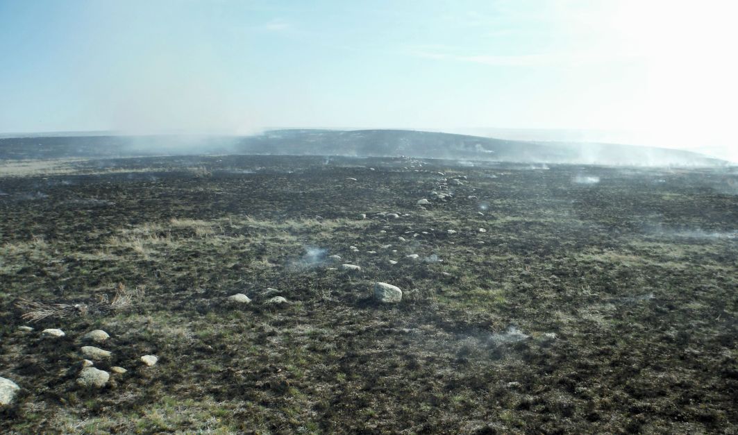
The image is from an unmanned aerial vehicle (UAV) and was collected by the Bureau of Land Management (BLM) in Phillips County, Montana. Federally-funded agencies are often required to document the presence of archaeological sites to comply with laws like the National Historic Preservation Act, but regional variations can affect their ability to do so.  For example, archaeological sites in the Great Plains often contain stone alignments and other stone features which can be easily lost in tall prairie grasses. As a result, archaeological inventories become costly to complete because of the person hours necessary to survey an area. Through prescribed burns, however, the obstructive vegetation is eliminated, offering a better view of archaeological features.

In this particular case, the BLM conducted the burn on a known archaeological site -- the 800 acre Henry Smith site dating from 770-1040 AD. While some features had been recorded previously, archaeologists expected to find many more features after the burn. The UAV collected 40,000 photos which are still being processed. The image included above shows a stone alignment used by prehistoric hunters to direct the flow of bison as they were driven off of cliffs for mass kills.

The reason I find this image so interesting is because it demonstrates an extension of remote sensing applications to contexts previously considered not visible from the air. While I don't encourage archaeologists to go around setting fire to grasslands in order to access sites, I recognize that this will dramatically increase the archaeological study of the prehistoric Great Plains. As a result, we can gain a much better understanding of past subsistence patterns, domestic activities, cultural interactions and migrations, warfare, and ethnogenesis.