Monday, July 29, 2019

Iraqi Emplacement in Former Mesopotamian Wetland

This image was acquired by Landsat 7  Enhanced Thematic Mapper plus (ETM+) on January 24, 2001 and was curated as a part of USGA's Earth as Art series, which highlights the beauty of the earth through satellite data. It depicts a former wetland area north of Al-Basrah, Iraq on its border with Iran, which has been walled off and drained, now used for military exercises. It is false-color composite image made using near-infrared, red, and green wavelengths,  which sharpened using the sensor’s panchromatic band.  This area known as the Mesopotamian marshland was initially partially drained by the British to reclaim land for agriculture and clear area for oil exploration, but was later used by Saddam Hussein as a tool of war and revenge to evict Shias that have taken refuge in the marshes after the 1991 rebellion. 

Monday, July 22, 2019

Pine Island Glacier, Antarctica

This is an image used in the study of shrinking glaciers, specifically Pine Island Glacier near the base of the Antarctic Peninsula. This image itself is particularly interesting because it shows the emergence of an abnormal rift in the glacier, where it will eventually break off and become an iceberg. By using remote sensing, the scientists can study how these glaciers are melting and breaking off, and the increase in frequency that that pattern is happening throughout Antarctica. That pattern recognition is important for the understanding of how warming waters is effecting glacier melting specifically with which is more pertinent;  thinning at the glaciers edge, ice front retreating inland, and acceleration of these trends.

Sao Palo at Night: The Urban Sprawl of Brazil's Largest City

Image result for sao paulo satellite images at night
This is a medium resolution satellite image of Brazil's largest city at night- Sao Paulo. What makes this a cool photo is the evidence of Sao Paulo's urban sprawl. Apparently the dark green and lighter brown colors reflect the different types of street lamps used to illuminate the city. This is one example of the trend of developing countries becoming more and more urbanized. 


Sunday, July 21, 2019

A Brick Kiln in India: Using satellite imagery to fight modern slavery


This image is taken from an article in Science which discusses how analysts at the Rights Lab in the UK are using satellite imagery to identify signs of slavery around the world. This particular image is centered on a brick kiln, made recognizable by its brown color and ovular shape which stand out amidst the surrounding agricultural fields. Since brick kilns are often run using forced labor, identifying their locations can help human rights defenders crack down on slaveholders. The image was obtained from one of the DigitalGlobe satellites; these satellites have very high resolution, which provides adequate detail for identifying such features. Given that brick kilns number into the tens of thousands in South Asia, the Rights Lab is now training artificial intelligence to identify the kilns, allowing for much quicker identification. The article concludes with a discussion on how other satellites or spectral signatures could be used.


Aftermath of the Kilauea Volcanic Eruption

Aftermath of the Kilauea Volcanic Eruption

This image shows the new reality of what used to be a small village on the island Hawai'i. A large volcanic eruption in 2018 changed the landscape permanently, and the area is now uninhabited. In this after photo, we can see remnants of this settlement in areas of land that are higher in elevation, such as the crater feature on the left and the couple of houses preserved on the hill towards the top of the image. Lava appears as a very distinct and unique texture in the image, looking inconsistent and wrinkled. This is an important application of remote sensing as it is used to evaluate the damage from a natural disaster, and can inform people of the extent of this lava flow. 

To view other areas affected by the eruption as well as the before photo to this image, visit this link. This image is sourced from a high resolution Planet sensor.

Sunday, July 14, 2019

Potash Evaporation Ponds Moab, UT


Shown in this picture are a series of evaporation ponds for potash, or salts that contain potassium used for fertilizer located near Moab, UT. A solution is pumped into the ground at the potash mine (not pictured) 2,400 to 4,000 feet underground to dissolve the potash. The solution is then pumped to the evaporation pools, dyed blue to increase evaporation and left to dry in the sun for ~300 days before it is scraped up and shipped off for further processing. The varying coloration in the ponds is due to the difference in water concentration in each pond. This picture was not cited except to credit NASA however similar pictures, with the same angle and resolution, of this mine are attributed to Landsat 8.

Image of the Day, July 15, 2019


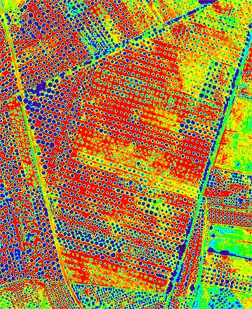
I choose an image capturing Plasticulture in the alleys of Almeria, Spain.  This picture is not only aesthetically pleasing, but it also photographs a booming agricultural method in Europe, as the fruits and vegetables produced by Plasticulture is now responsible for $1.5 billion of Almeria's annual revenue.  
The top of the image displays the mountainous alleys, composed of little vegetation; whereas the bottom of the image, illustrates the greenhouses built from plastic materials, which serve the purpose of storing growing fruits and vegetables. 

Friday, July 12, 2019

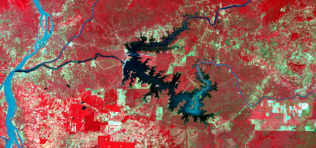
Lower Sesan 2 Reservoir, Agriculture Land and Forest

This is the false colour infrared imagery of Landsat8 taken on December 2nd, 2018 and the location is Lower Sensan 2 reservoir in Cambodia.  From the image, we can see a giant reservoir and based on the shape of the reservoir, we can identify that the water flows from the East to the West.  The surrounding environment of this reservoir is agriculture land and forest.

The waters vary from dark to light blue, the vegetation appears in shades of red. The red colour with parcel shape indicates healthy agriculture areas while the dark red represents forest land.  The urban areas are light cyan blue, and soils are light browns.

Source: Landsat8 Image with a false colour combination (5-4-3)


Monday, July 8, 2019

Platte, Missouri, and Elkhorn Rivers


This GIF image shows flooding on the Platte, Missouri, and Elkhorn Rivers near Omaha Nebraska. We can see the immediate effects of color change in agriculture and flooding of the river bands into huge areas of land. The two images were taken in late March of 2018 and 2019 respectively, from the Landsat-8 Satellite sourced from NASA Earth Observatory, and edited by Tom Yulsman. 

Trees Affected by Bacteria in Puglia, Italy

https://www.osa-opn.org/opn/media/Images/Homepage/Newsroom/0718/News-3Jul-image1.jpg?width=1200

This image is a false color hyper spectral image using blue, red and NIR wavelengths to highlight olive trees in southern Italy affected by a bacteria called Xylella Fastidiosa, with the affected trees shown in brighter colors for the RGB display. This type of imagery is important because it shows one of many cases where different combinations of spectral resolution can help treat crops more quickly before they are lost to a disease or infestation. This technology is applicable to many crop production issues in all parts of the world and can help decrease the use of pesticides to only the areas that are actually affected. This not only improves production and decreases costs, but also does less damage to the surrounding ecology. On a side note this improvement in production could be a crucial part to feeding the ever growing human population on earth. The image was taken using a camera flown 500m above the ground, and was edited by Pablo J. Zarco-Tejada.


Image of the Day

        This is the Isle de Jean Charles, in Louisiana. A community belonging to the Biloxi-Chitimacha-Choctaw nation, it was settled in the early 1800s and grew rapidly in size after the Indian Removal Act went into effect. Miss management of dredging operations and canal creation starting in the 1920s was the beginning of the end for this small island. Since about 1950 the isle has reduced in size by nearly 98% and the population has dwindled from more than 350 to less than 75 people. The entire ecosystem has been destroyed and as has their economy, ancestral lands, and way of life. In 1998, it was determined that it was not cost-effective to include the island in the Gulf Flood Protection system and the one road to and from the island will no longer be repaired. This road floods if tides are higher than normal, any time there is a storm/hurricane in the gulf or if the wind blows from the southeast. The community is currently in the process of relocating and are considered to be the first climate refugees in the world. At one point in time, the island was more than five miles wide, with large trees and abundant fishing, what remains is about ¼ mile across and 2 miles long and most of the wildlife is gone. The images show the textural change as the land is swallowed by the water through the passage of time. I put them in a clockwise order starting from the top left so that the earliest and latest images would be easy to compare. The 1990 image gives clear pictures of the canals that were cut by oil companies, comparing these lines through the images also shows that these man-made structures are unable to withstand the damage of rising waters and the degradation they themselves have caused. It can be seen through the pictures how much of the vegetative cover has changed between 1963 and 2019, however, consider the real damage started in the 1950’s so even the 1963 photo is not a real representation of the overall change and loss. One especially distinct feature that changes a great deal through the photos is the canal that zig-zags through the top right side of the pictures. What was once a very distinctive feature in 1963 and 1990, is almost completely gone in 2019. These images are important because they document the effects of climate change, they illustrate the negative impact that industries have on small communities and showcase the importance of remote sensing and aerial photography as a way to track change over time in our communities and possibly help to draw attention to the growing crisis of our coastal communities.

Images copied from Google Earth Pro: 1990, 1998 and 2019 Link to the image from 1963: http://www.isledejeancharles.com/the-environment

The whole story: http://www.isledejeancharles.com/

I also used information from the following videos:
https://eros.usgs.gov/image-of-the-week/isle-de-jean-charles-louisiana
https://www.pbs.org/newshour/show/native-community-louisiana-relocates-land-washes-away
https://www.globalonenessproject.org/library/films/isle-de-jean-charles


Monday, July 1, 2019

Image of the day "Soviet missile launch site during Cuban Missile Crisis "


This is a low altitude image taken by U-2 reconnaissance plane during Cuban Missile Crisis in October 23, 1962. The image showed several detail of missile launch facility that Soviet Union secretly constructed in Cuban. All suspected features are labeled . vehicle trails were clearly visible in the whole image, several vehicles also exist near the trails. These features indicated the area had heavy traffic recently, and these vehicles were support vehicles for the launch site . The long tent structure is uncommon compare to tents for barracks. The intelligent analyst suspected this was a tent use to protect missile. The information given by this and other images made EXCOMM ( Executive Committee of the National Security Council) assume Soviet missiles were becoming real threat.


https://www.theatlantic.com/photo/2012/10/50-years-ago-the-cuban-missile-crisis/100387/