By Ethan Tsvayg
2/13/24
In December 2023, after the discovery of oil in the Essequibo Region of Guyana,
Venezuela, who has held claims to the region for centuries, passed a controversial
referendum to annex the region as a part of Venezuela, and seems to be planning
for a ground invasion to control the land. This article from the Guardian refers to a
report by the Center For Strategic And International Studies (CSIS), which talks
about the increase in military force near the Venezuela-Guyana border, through
satellite aerial photos. Here we see six photos showing the increase in military
presence through two slides comparing aerial photos from before and now, and
two aerial photos. With this aerial information, a Venezuelan military invasion of
Guyana seems likely, unfortunately. Hopefully, things will de-escalate between the
two nations, and peace ensues.
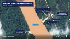
The first image compares an area around Rio Cuyuni between December 2023 and
January 2024 toshow the change in usage. On the left we see the river in a natural
state, with sediment being carried by the river as natural, thus causing a brown
color. On the right, due to the passage of large vehicles, a ferrybarge, and storage
unit were built. The left shows mainly civilian usage, while the right shows heavy
military usage, and with the dirt runoff from the new storage sites, the color of the
river has changed to a gray color.
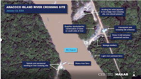
The second image compares the Ananoco Island military base in Venezuela from 2021
to January 2024. On the left, it shows a small platoon, with little movement and damage.
On the right we see a large military group, with many more barracks and field office
buildings. We even had a small base expansion, showing more military expansion.
Interestingly if you look at the ground, on the left it used to be grassy, due to low
usage, while now, it's much more dirt, due to the vehicle tracks and heavy use.
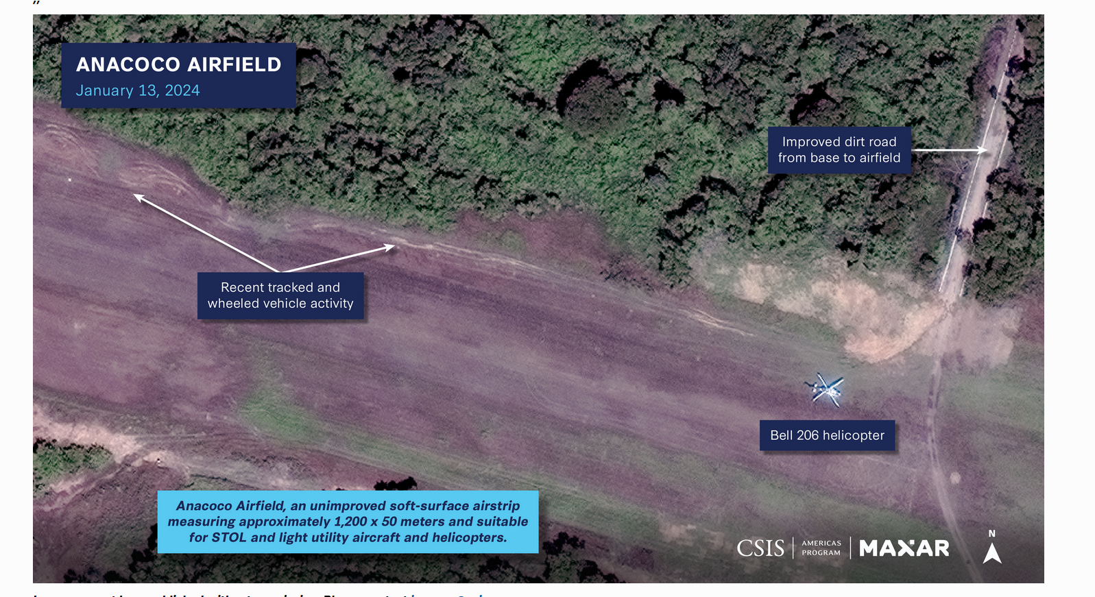
The third image shows the Anacoco Airfield as of January 2024, which is having a
surge in military activity, as seen by the tire tracks from the sensing imagery. Tire tracks
usually indicate recent plane activity, especially as seen on a dirt runway. We can see
a helicopter in this photo, showing more activity from the Venezuelan military.
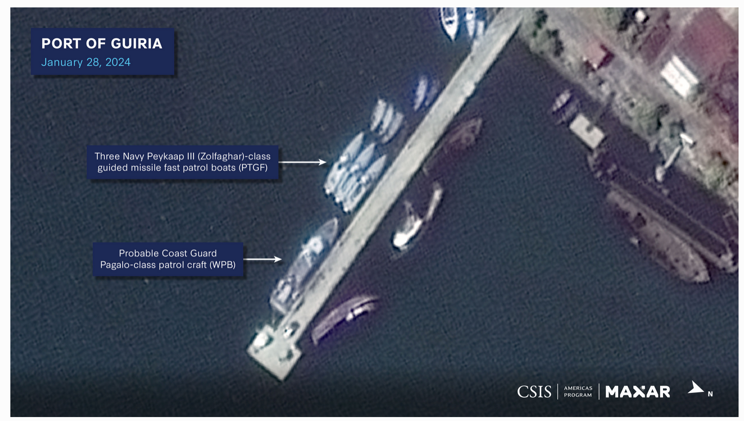
The last image shows the Port of Guiria as of January 2024, but you can see that the
usage of a Coast Guard port has increased significantly. You can see the size of the
Coast Guard fleet, with a large patrol boat, and three fast patrol boats, which all arrived
recently, according to the article. The boats in the back seem like small Coast Guard
boats are being replaced by bigger patrol boats. With the article stating that this port
will become a naval air station, it seems that the Venezuelan military will use this base
as a point to attack Guyana.
Article Link (Guardian): https://www.theguardian.com/world/2024/feb/09/venezuela-
troops-guyana-border-essequibo-satellite-images
Article Link (CSIS): https://www.csis.org/analysis/miscalculation-and-
escalation-over-essequibo-new-insights-risks-venezuelas-compellence
No comments:
Post a Comment