Thursday, October 25, 2018

Image of the Day: October 30, 2018


This is a vertical image of the Aral Sea, which lies on the border between Kazakhstan and Uzbekistan. The Aral sea was once the 4th largest lake in the world, and was roughly half the size of Great Britain. Since the 1960's the sea has been shrinking due to local irrigation projects that diverted inflows, and it is now a small fraction of its formal size.

Tuesday, October 23, 2018

South Bay Salt Ponds, 10/24


This oblique photo captures the South Bay salt pond complex of the San Fransisco Bay. Going back over a hundred years, these pools were created for salt production by dredging and filling the naturally occurring salt marshes and wetlands of the Bay Area. The varying colors of the ponds indicate different stages of the evaporation process. The red coloration is indicative of higher salt concentration/greater evaporation, with the color itself caused by the presence of algae, microbes, and brine shrimp that thrive in this high-salinity environment. These salt ponds are now the site of an extensive environmental restoration project to convert the land back to natural wildlife habitat. 

Tuesday, October 16, 2018

Image of the Day


The Landsat-5 image shows Lake Erie and a small portion of Lake St. Clair enveloped in a harmful algae bloom in 2011. The fluorescent green swirls in the lake are mats of cyanobacteria, and the high levels of agriculture and urbanization around the lake offer a clue as to why the algae bloom is happening in the first place. Imaging algae blooms like this one is important for quantifying the bloom and for analyzing the success or failure of management efforts on the lake. Harmful algae blooms have devastating negative effects on lakes like Lake Erie and are an increasing cause for concern with increased human activity and climate change.

The Devastation of Palu, Indonesia


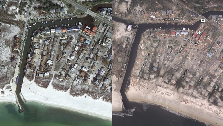
This image shows the city of Palu, Indonesia before and after the 7.5 magnitude earthquake and subsequent tsunami that occurred on September 28th. Exemplifying the impact of this disaster, we see the drastically increased sediment load washing out of the river. This is identified by the shift in the water color from brownish-blue to a distinct earthen-brown. Comparing the coastline in the two images, large swaths of beach and structures have completely disappeared. Upon closer look, the bridge at the mouth of the river has either collapsed or is flooded, which has implications on access to emergency services and transportation. Along the perimeter of the city there are also clear signs of landslides; where buildings once stood we now only see brown earth. While this image does not give an on the ground look of the devastation individuals are facing in the wake of this disaster, it is important because it gives us a larger city-wide view of the destruction. The large plume of sediment washing away also has implications for the state of the landscape in areas not included in this image, further upstream.

A Smoky Situation, 9/24/18


The Pacific Northwest experienced another intense wildfire season. This photo was taken on August 15, 2018 where a large smoke-cloud is hovering over eastern Canada. Although there are numerous white or normal-looking clouds in the satellite imagery, the wildfire smoke is distinguishable by it's gray tone and its dense appearance versus the clumps and wisps of normal clouds. Analyzing the size of this smoke cloud can define a region and area of people who will be affected by poor air quality from the smoke. Poor air quality is threatening to those with asthma and heart conditions because the contaminated air impedes one's lungs. Sometimes, poor air quality can be a threat to the average person because of how the contaminated air reduces lung function. This is how it was for many during this August's wildfires as the government of British Columbia called for a state of emergency due to the health risks of the smoke. Analyzing the region most affected by this accumulation of smoke is important because citizens can be warned to take precaution for their health. This could potentially reduce the instances of asthma attacks or heart-related emergencies during wildfire season by advising people to exercise indoors or reduce time outside for the time being. Analyzing remote sensing images like this may be used as preventative efforts in public health.

http://blogs.discovermagazine.com/imageo/2018/08/16/smokey-superlatives-widespread-wildfire-impacts-seen-from-as-far-away-as-a-million-miles/#.W6sT5y2ZNol

Image of the Day October 16th

Mexico beach new before after 10 11 18
This is an image provided by Google Earth of Mexico Beach, FL before Hurricane Michael and an image provided by the National Oceanic and Atmospheric Administration of Mexico Beach after Hurricane Michael.  The destruction is clear in this image with the contrast of the clear lines of roads and buildings on the left, and the speckled rubble on the right.  Street names have to be used as labels in the image on the right to provide context to where the streets once were.  The breakwater at the end of the canal is gone in the image on the right and the sediment deposition is drastically changed as a result of the storm surge.  The piers on the left have also been clearly destroyed.  This image was posted in a Pensacola News Journal article, Mexico Beach has already begun recovery efforts.

Thursday, October 11, 2018

Dirty Ice, October 11, 2018


This is an image of the Foxe Basin, up in the Northwestern Passages in northern Canadian, north of the Hudson bay. It seems that the ice has a brownish tint. The reason that this subtle difference is so important is discovering the reason for the brownish tint of the ice. One theory is from anthropogenic sources such as aerosols from industrial factories that have been emitted in the atmosphere and being deposited on the ice. Other sources could include sediment movement in the ocean. So looking at multiple images of the same area at different times and looking at other physical properties of the ice, we can possibly get a better sense of sediment movements in the ocean. 

Image of the day, October 11, 2018


Tuesday, October 9, 2018

Islands in Russian High Arctic, October 9, 2018

This image observed by satellite Landsat 8 displays four islands in Russian high Arctic. Based on the white color , snow texture, ice cubes, the brown mountain-like feature and no presence of vegetation shown in the image, it is a tundra in area of very high latitude. The image is important since it helps scientists do research about different terrains in the world and may be used in studying global warming as in the image, some ice on the border of the island in the lower right place are melting.

Tuesday, October 2, 2018

Image of the Day, October 2, 2018


This image shows the Midwest covered by snow during February of 2014. The Great Lakes are frozen over and drifts can be seen on the lakes where wind blows the snow around over the ice. Wind blowing west to east creates drifts that push the snow across the lake. Less snow is blown onto the lake from land than is pushed across the lake, which is why the west side of the lakes have less snow cover.