Article Link: https://www.newsweek.com/satellite-photos-ukraine-drone-attack-russian-airbase-1895062
Article Link: https://www.newsweek.com/satellite-photos-ukraine-drone-attack-russian-airbase-1895062
In this New York Times article from February 29, 2024, aerial photography is used to piece together the events that led up to the massacre of hundreds of civilians attempting to receive aid. The article references multiple examples of remotely sensed data. First, it references the drone footage published by the Israeli army. They note that this footage was spliced together and is missing key moments. Some of this footage is included in Figure 1.


In late January, one of the beaches close to my childhood home had a massive erosion event from increased sea levels and storms. All throughout my life, my family always avoided Wildwood beach because it took so long to walk to a water from the boardwalk, about a quarter mile. However, less then 10 years later, the water is only a few hundred feet away from the boardwalk. Because the beach is so long, no sand dunes were put in place to help protect against the rising ocean, which has no become a pressing issue. While there was a plan to start creating more dunes in 2017, the project never started, and a retaining wall, or bulkhead, had started to be built instead, but even that was scrapped. Because of the most recent storms and rising sea levels, a new bulkhead project was proposed, but it would only start in 2025 or later, leaving the beach's residents and businesses at the mercy of mother nature. In an article written about the beach and potential upcoming project, the writers include a single image of Wildwood beach, combined from an image from 1995 and another from late 2023. The two images are from one area, and have been scaled and matched evenly side by side so that the 1995 image shows the left most part of the area and the 2023 image shows the right part of the area. This allows us to be able to see the true extent of the sea level rise from where the two images meet, rather than using two images from the same exact area with the same nadir. From these images, it's easy to see how much of a threat there is to multiple buildings at the end of 2023, which will only continue to get worse.

The Destruction from the War in Ukraine


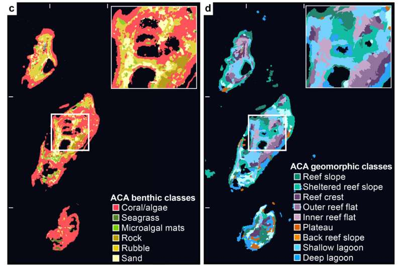
A 2024 study developed a method to predict reef biodiversity using remote sensing. Satellite imagery was used to develop maps that identify distinct marine habitats in the Fulaga Atoll of Fiji. This data was compared with measurements of the biodiversity of fish and coral collected by field researchers. The study found that areas of high habitat diversity had a positive correlation with areas of high biodiversity. The first of the four images below is a true-color image of the atoll, and the three following images are satellite-derived maps that assign a particular color to a distinct physical or biological region in the atoll. Areas of high habitat diversity have a relative abundance of colors per unit of area, and appear to have a more fine texture in which different colors are less distinguishable. Areas of low habitat diversity, on the other hand, have one or relatively few colors per unit of area, and are represented by single, smooth patches of color. A couple of regions, like ‘land’ and ‘sand’ are easy to identify in the true color image, but the maps make the habitats markedly easier to identify. This method could be used to infer measurements of biodiversity at other reef sites, at a much lower cost than deploying researchers in the field. 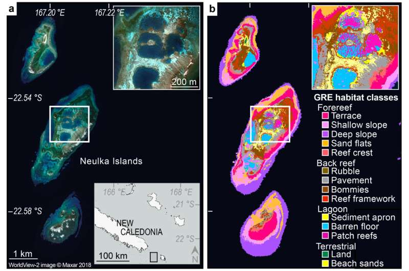
In December 2023, after the discovery of oil in the Essequibo Region of Guyana,
Venezuela, who has held claims to the region for centuries, passed a controversial
referendum to annex the region as a part of Venezuela, and seems to be planning
for a ground invasion to control the land. This article from the Guardian refers to a
report by the Center For Strategic And International Studies (CSIS), which talks
about the increase in military force near the Venezuela-Guyana border, through
satellite aerial photos. Here we see six photos showing the increase in military
presence through two slides comparing aerial photos from before and now, and
two aerial photos. With this aerial information, a Venezuelan military invasion of
Guyana seems likely, unfortunately. Hopefully, things will de-escalate between the
two nations, and peace ensues.
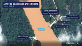
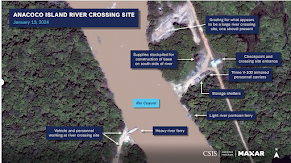
The first image compares an area around Rio Cuyuni between December 2023 and
January 2024 toshow the change in usage. On the left we see the river in a natural
state, with sediment being carried by the river as natural, thus causing a brown
color. On the right, due to the passage of large vehicles, a ferrybarge, and storage
unit were built. The left shows mainly civilian usage, while the right shows heavy
military usage, and with the dirt runoff from the new storage sites, the color of the
river has changed to a gray color.
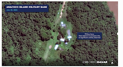
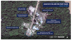
The second image compares the Ananoco Island military base in Venezuela from 2021
to January 2024. On the left, it shows a small platoon, with little movement and damage.
On the right we see a large military group, with many more barracks and field office
buildings. We even had a small base expansion, showing more military expansion.
Interestingly if you look at the ground, on the left it used to be grassy, due to low
usage, while now, it's much more dirt, due to the vehicle tracks and heavy use.
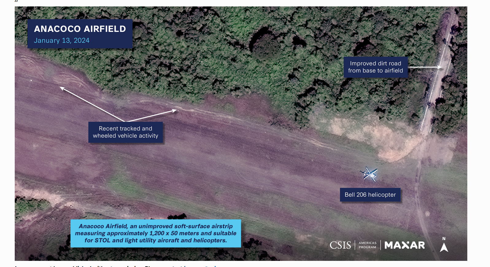
The third image shows the Anacoco Airfield as of January 2024, which is having a
surge in military activity, as seen by the tire tracks from the sensing imagery. Tire tracks
usually indicate recent plane activity, especially as seen on a dirt runway. We can see
a helicopter in this photo, showing more activity from the Venezuelan military.
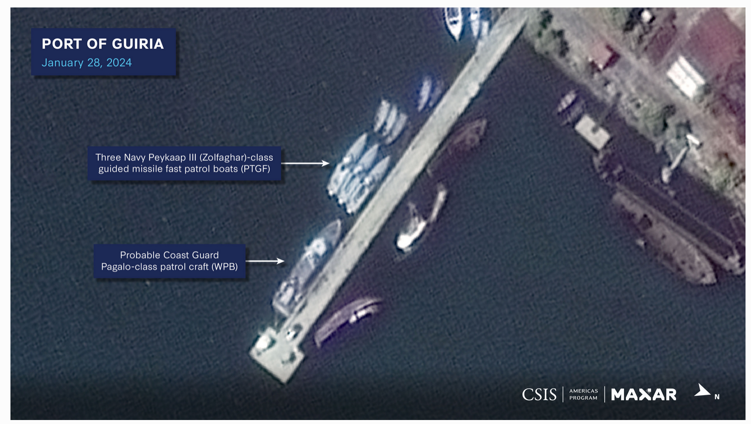
The last image shows the Port of Guiria as of January 2024, but you can see that the
usage of a Coast Guard port has increased significantly. You can see the size of the
Coast Guard fleet, with a large patrol boat, and three fast patrol boats, which all arrived
recently, according to the article. The boats in the back seem like small Coast Guard
boats are being replaced by bigger patrol boats. With the article stating that this port
will become a naval air station, it seems that the Venezuelan military will use this base
as a point to attack Guyana.
Article Link (Guardian): https://www.theguardian.com/world/2024/feb/09/venezuela-
troops-guyana-border-essequibo-satellite-images
Article Link (CSIS): https://www.csis.org/analysis/miscalculation-and-
escalation-over-essequibo-new-insights-risks-venezuelas-compellence
Feb 08, 2024
Yulong Jiao


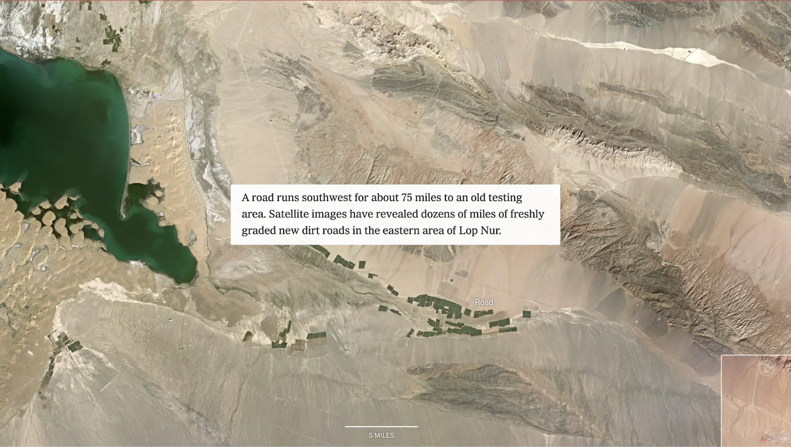
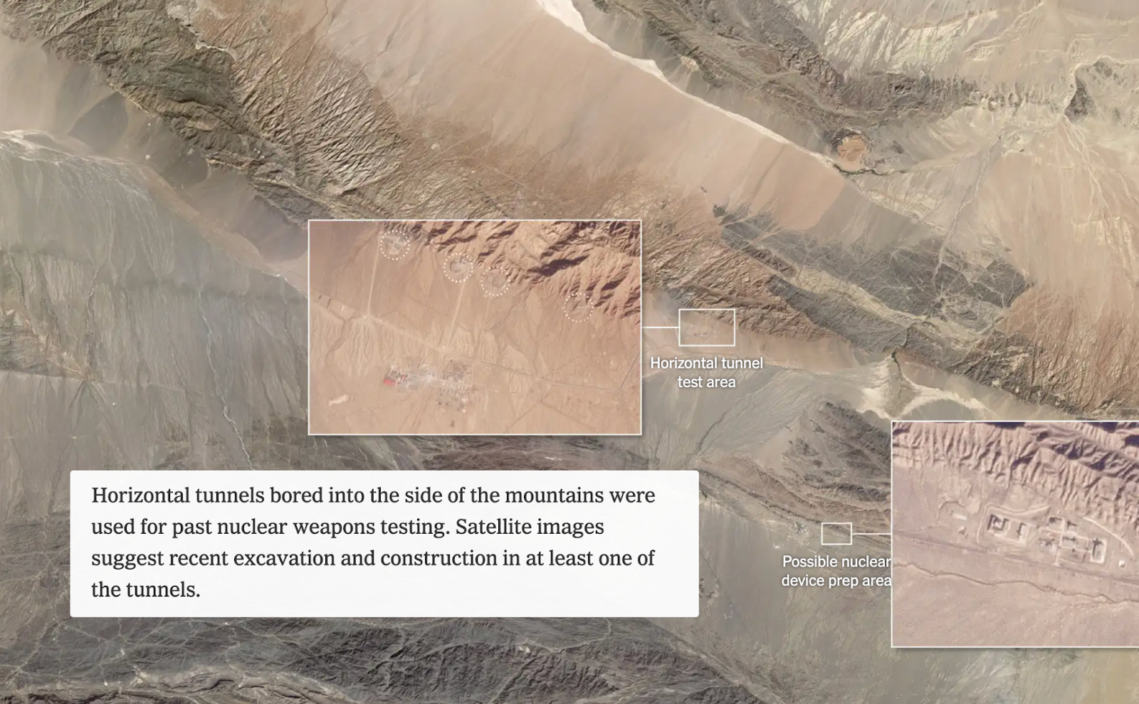
Old nuclear testing sites in Lop Nur. At the beginning of the article, there is a scrolling map which includes text callouts and inset images to show more detailed images of certain features. This sets up a visual for readers, and the action of the screen moving across the landscape allows us to get a sense of the scale of the project. The authors also labeled features that may not be obviously identifiable from such a distance, such as roads and tunnels, in order to facilitate readers’ understanding.
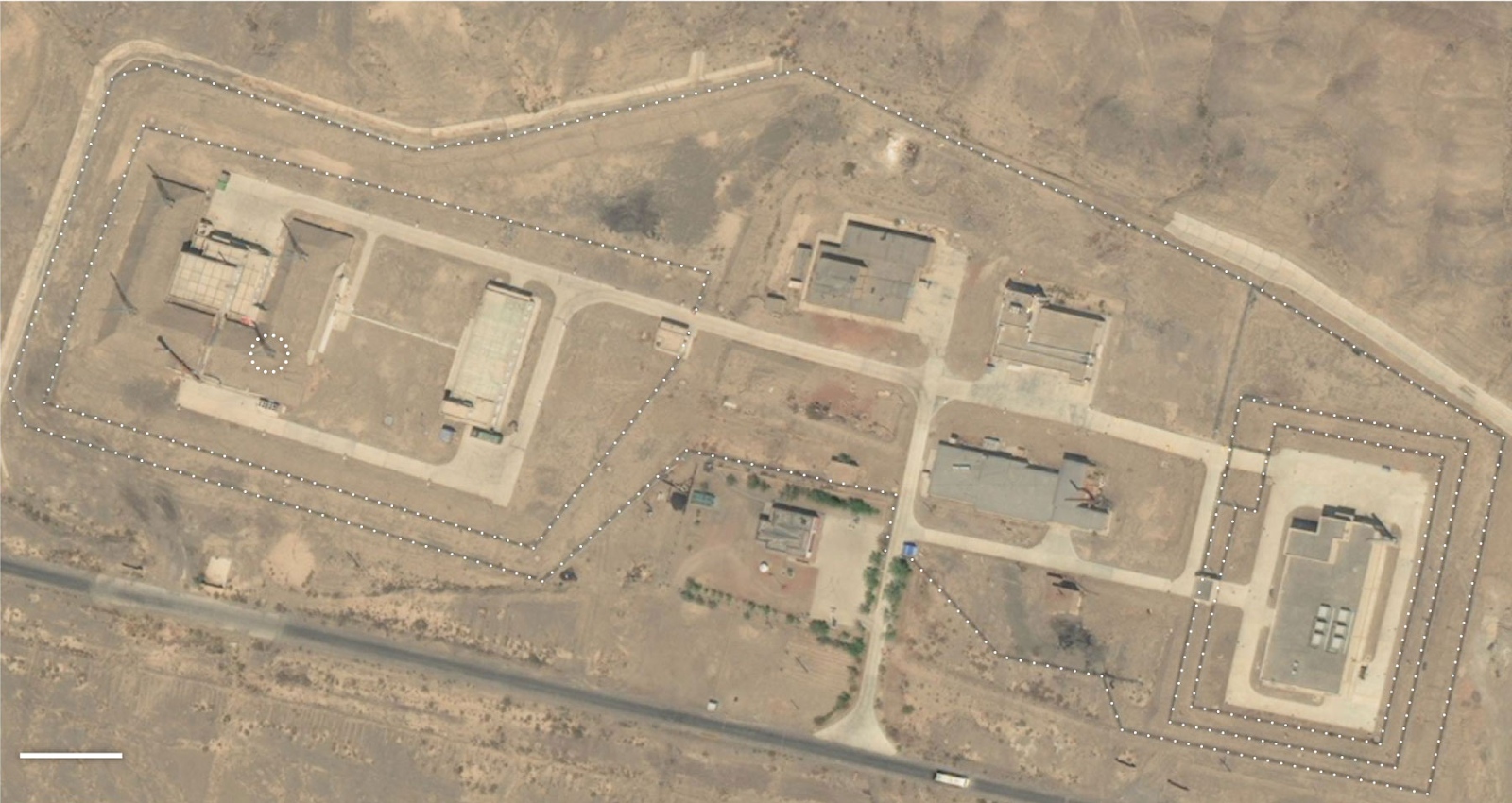
Facility in Lop Nur speculated to be used for nuclear-related activities. This image provides a closer view of the buildings and rural landscape and their muted tones, allowing readers to visualize the testing site at a more detailed level than the previous scrolling map.
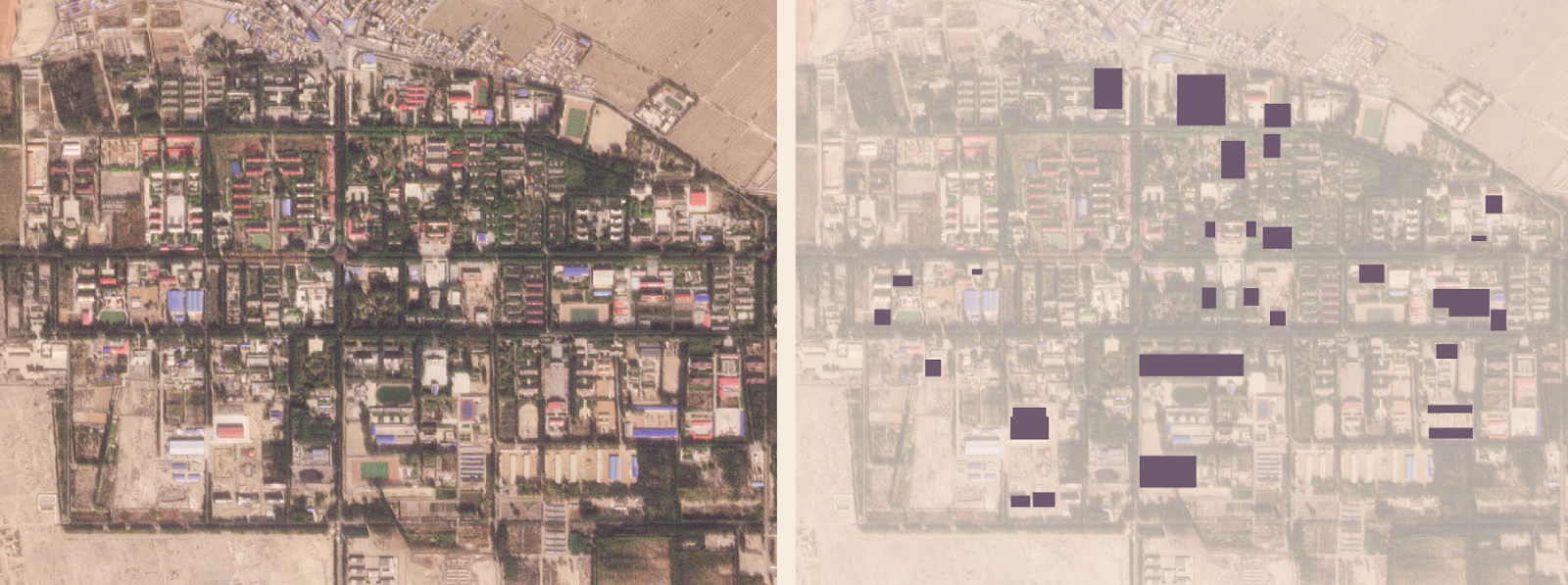
New buildings added or renovated in Malan, the nuclear support base in Lop Nur, since 2017. The map quickly conveys the amount of new facilities that have been put to use, indicating growth in the nuclear testing project.
The structure of this article is effective in displaying satellite images throughout and explaining how they provide evidence that China is building a nuclear test base in this region. The images are especially effective in providing a strong visual for what a nuclear testing site looks like, something that not all readers may be familiar with, and depicting change and increased construction over the last few years.
The use of remote sensing is important in this situation as it allows for the rest of the world to get information about something that China may not otherwise disclose, in a place that might not otherwise be accessible for journalists. This is something that raises security concerns regarding nuclear weapon use, and satellite imagery enables the development to be tracked.
One of the questions these satellite images do not answer is whether people are affected by this development. The satellite images show a barren, empty landscape around the nuclear satellite, but do not indicate where the nearest towns are and whether they are close enough for people there to be affected by health hazards from nuclear testing.
From the New York Times, “China Quietly Rebuilds Secretive Base for Nuclear Tests”
https://www.nytimes.com/interactive/2023/12/20/science/china-nuclear-tests-lop-nur.html

These images show the state of a seaside warehouse in Beirut, Lebanon before and after a massive explosion. The explosion was caused when a crate of ammonium nitrate caught fire. As the image shows a massive crater is left along with heavy damage to buildings around it. These satellite images complete devastation to the port and the buildings around it, along with a ship that was blown out of the water and onto the dockside. These images are important for disaster diagnosis and prevention along with emphasizing the importance of locating dangerous materials in a populated place.
https://www.wionews.com/world/beirut-explosion-created-massive-crater-at-port-satellite- imagery-shows-318495