Remote sensing in the media has become ubiquitous, with satellite imagery appearing in everything from the news to sitcoms to blockbuster movies, and even commercials. Given the varying levels of quality and interpretability, there is much to think about and discuss!
Thursday, October 27, 2016
Image of the day
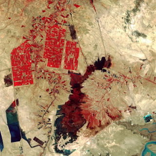
http://time.com/4511233/space-week-landsat-earth-observation/This is an image of Shadegan Wetlands in Iran taken by Landsat 8. This image is relevant to our class as it is a false color image showing the infrared reflectance of the vegetation in the agricultural fields located in the upper left corner of the image. In the areas surrounding the agricultural fields, however, there is very little or no vegetation cover at all, aside from the area occupied by the Shadegan Pond in the center of the image. There appear to be man-made reservoirs in the lower left corner of the image as they feature very straight edges which are not characteristic of natural bodies of water.
Subscribe to:
Post Comments (Atom)

No comments:
Post a Comment