At one point, Aral Sea was considered as one of the four largest lakes in the world. However, it has been steadily shrinking since the 1960s when Soviet Union started its irrigation project. By 2006, central portion of the lake had disappeared, and by 2014, eastern basin had dried up and became a part of desert. These images reveal that Aral Sea will disappear in near future if no necessary change is made.
Remote sensing in the media has become ubiquitous, with satellite imagery appearing in everything from the news to sitcoms to blockbuster movies, and even commercials. Given the varying levels of quality and interpretability, there is much to think about and discuss!
Monday, October 31, 2016
Sunday, October 30, 2016
Thursday, October 27, 2016
Image of the day
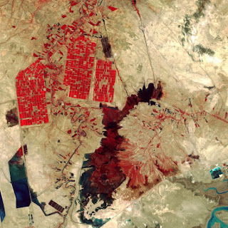
http://time.com/4511233/space-week-landsat-earth-observation/This is an image of Shadegan Wetlands in Iran taken by Landsat 8. This image is relevant to our class as it is a false color image showing the infrared reflectance of the vegetation in the agricultural fields located in the upper left corner of the image. In the areas surrounding the agricultural fields, however, there is very little or no vegetation cover at all, aside from the area occupied by the Shadegan Pond in the center of the image. There appear to be man-made reservoirs in the lower left corner of the image as they feature very straight edges which are not characteristic of natural bodies of water.
Wednesday, October 26, 2016
Tuesday, October 25, 2016
Monday, October 17, 2016
Thursday, October 13, 2016
Wednesday, October 12, 2016
Tuesday, October 11, 2016
October 11 Image of the Day: Hurricane Matthew in Hati
This image illustrates the destruction that Hurricane Matthew left in Haiti by juxtaposing before (2013) and after (10/9/2016) images of the southern peninsula. In the "after" image, all the vegetation is gone, and the buildings have been ripped apart. This pairing of images is important for understanding the geographic extent of the devastation, in order to know where to send rescue teams or concentrate resources with aid, and also as a visual tool for those outside Haiti to get a better grasp of what is going on and be encouraged to help or contribute resources.
Source: http://abcnews.go.com/International/haiti-hurricane-matthew-satellite-images/story?id=42713351
Original image data available at: http://opendata.digitalglobe.com/
Monday, October 10, 2016
October 11th "Photo" of the day
This amazing map uses many of the techniques we recently learned to show areas of forest and deforestation (in red on this map). I was tipped off to it through an article posted on Nature's website:
http://www.nature.com/news/warning-to-forest-destroyers-this-scientist-will-catch-you-1.20730
I searched out the person the article was about and found their website. This guy, Matthew Hanson, takes imagery from the satellites and uses it to find and map out areas of deforestation around the globe. Its FASCINATING. I was thrilled to find it and really enjoyed seeing the work this guy has done:
Thursday, October 6, 2016
Oct 6th - Image of the Day
While this satellite image is easy to place due to the added state boundaries, I’m from North Carolina where fall colors are a huge event. Everyone drives up to the mountains with hopes of visiting during peak color. This image is true-color, as suggested by the green of the vegetation rather than the vibrant red representing near-infrared reflectance from vegetation if this were a false-color image. Mountains are the second most discernible feature as they have a copper color, and some taller mountains have shadowing as evidence of height. The gradient of the vegetation’s color is subtle, but taller mountains have a darker vegetation tone, appearing almost burnt orange, having changed earlier due to their higher elevation and cooler climes, while the foothills have more of a yellow tint, having begun the transition later. Also, the further north along the mountains, the darker and more orange the colors become. Rivers are noticeable by their dark blue color and sinewy nature, with small thin filaments joining to form larger channels (pattern). While it is somewhat difficult to tell at this altitude, signs of human civilization are evident. They come in the form of dense, light areas, such as the few in the center of North Carolina, found towards the right side of the image. Up close, they exhibit a radiating pattern, with roads leading off to other cities, and a high reflectance due to the lack of vegetation.
(I was hoping to find a grayscale or false-color close up of the changing colors along the mountains, as it would have been more of a challenge to interpret, but couldn't find anything that was quite right.)
Subscribe to:
Comments (Atom)


