Remote sensing in the media has become ubiquitous, with satellite imagery appearing in everything from the news to sitcoms to blockbuster movies, and even commercials. Given the varying levels of quality and interpretability, there is much to think about and discuss!
Thursday, December 5, 2019
Bushfires in Austrailia: December 6, 2019
This image captures the hundreds of bushfires that are burning in Australia on the east coast. The image was taken on November 12, 2019 by Copernicus Sentinel-3. It shows the smoke from the fires which has drifted over the Tasman Sea. In this image, it is easy to see the smoke from the fires as it is overlaying the sea. This image is important because not only can you see the extend of the area over which these fires are burning, but you can see the different sources from where the fires are burning. The Copernicus Emergency Mapping Service also uses satellite images such as these to help respond to the fires and study these fires in order to see the impact they have on the emissions that they give off to the atmosphere.
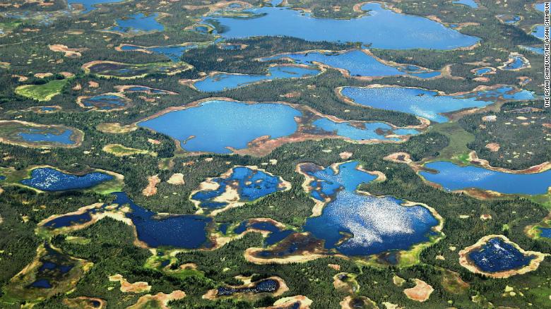
Permafrost Melt in Northern Alaska

This image shows thermokarst features, or disturbances created by melting and subsiding permafrost in Alaska on June 21, 2017. The water features from melting soil ice on the landscape are becoming larger and more common. Alaska is one of the fastest warming places in the world as a result of global climate change-- on average, Alaska is warming 1.5x faster than the rest of the United States, with most of that warming happening in the winter and in the spring. Alaska's low population density and remoteness shelter it from widespread news coverage about the impacts of climate change. Images such as these, especially as a series, help us visualize how quickly and to what extent landscapes are changing.
Wednesday, December 4, 2019
Greenland Ice Sheet Waterfall
This is a drone image of meltwater that has formed on the glacier sheet in Greenland due to climate change. It shows the before and after of the water falling through the cracks in the ice sheet, which contributes to more water and ice being pushed out to sea. It was temporarily the tallest waterfall in the world, and the water was cascading at approximately 950 cubic meters per second. This is an important phenomenon to study because the melting of these ice sheets contributes to global sea level rise.
This is the article: https://www.cnn.com/2019/12/04/world/drone-greenland-ice-sheet-fractures-scli-intl-scn/index.html
Drought causes lakes to dry up in Chennai, India
These three images are of a lake in Chennai, India. The first image was taken on June 15th, 2018, the second was taken on April 6th, 2019, and the third was taken on June 15th, 2019. This summer, India was experiencing major drought due to a late monsoon season and hot temperatures. The state had to ration water for its citizens since all of their reservoirs were dry.
Link to the article: https://www.cnn.com/2019/06/20/world/chennai-satellite-images-reservoirs-water-crisis-trnd/index.html
Tuesday, December 3, 2019
Before and After the California Wildfires 2018: The Mendocino Complex and County Fire-Ayla Kunes
https://weather.com/news/news/2018-11-13-california-scorched-burn-areas-2018-wildfires
See original website for better "after" image.
The Path of Destruction from the Stoughton Tornado (2005)
This image is an aerial photograph of Stoughton, WI in the aftermath of the tornado which went through the area on August 18th, 2005. This image contains a combination of Landsat MODIS and Aster and represents the change in landscape where the path of the tornado is shown in a red color. The imagery is important as it can be used by emergency agencies in determining the location and extent (house, town, county) of the damage where the help should be focused. Additionally, this imagery could be used to help determine what kind of assistance is required to the areas affected.
Monday, December 2, 2019
Deforestation of National Zoo-cum Park & Botanical Garden, Bani Gala
The image shows major changes in forest development after
the addition of centralized urban land. The changes in reflectance of the
vegetation, within a 4-month period, shows large residential development had
taken place. Forested lands are seen as natural beauty in Pakistan. In turn, real
estate investments are taken advantage of in these areas. The large housing
societies have caused massive deforestation in just a few months. Almost 8km^2
of forested land was demolished by these new residential land coverages.
Subscribe to:
Comments (Atom)


